
Services
Survey
GSP INTERNATIONAL provides profesional survery services in the Energy and Trasportation sectors, using the latest technology for data collection and post-prcessing.
We use state-of-the-art unmaned aerial vehicle (UAV) and the most advanced photogram metric drone software to survey, process and export mapping data automatically. We have fully trained pilots and our procedures fulfill the necesary FAA regulations.
We provide point cloud files form which we can obtain digital terrain model, topographic Surface, elevation contours and geo-referenced aerial images.
We can obtain:
-
<1 inch accuracy
-
3D model
-
Point clouds
-
Digital contours
-
Aerial ortho-mosaic
-
Up to 10 times faster than traditional methods


GIS & Mapping
GSP INTERNATIONAL provides integral solutions for infrastructure projects, covering:
-
Data Collection
-
Base Mapping
-
Topographic Drawings
-
As-built drawings
-
Alignment Sheets
-
Parcel exhibits
-
Plan and profile drawings
We do any type of Energy projects such as:
-
Gas
-
Water
-
Sanitary
-
Electricity


UAV
GSP INTERNATIONAL UAV (Unmanned Aerial Vehicles) team of professional technicians provides high quality images and digital data as an alternative to traditional method survey:
-
High-Definition Survey
-
Aerial Imagery
-
Aerial Video
-
Utility Transmission/Distribution lines
-
3D Digital Terrain Model


CAD Services
As-Built drawings
Many times, our projects does not end up the way we imagined at the beginning, due to interferences on the field, changes in the scope and/or budget, additions or subtractions to the original design. That's why it's important to update our drawings to make them match to what's actually built.
We can translate your redlines and field notes to adapt your Project drawings to what was actually built.

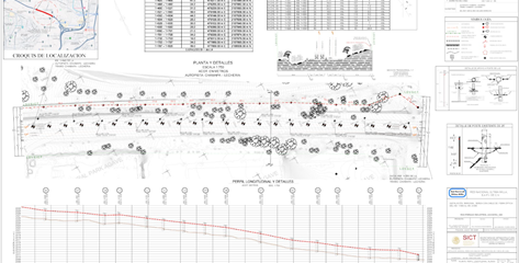
Alignment Sheets
Our team has worked with a large number of alignment sheet formants for different sectors:
-
Gas
-
Water
-
Transportation
-
Sanitary and Storm Sewer
We can show plan and profile with the standards and properties specified by our client.
Digitizing Of Deeds
We digitize property tracts out from scanned deeds, based on each boundary line's bearing and length, for Cadastral projects.
We can convert any unit format to the desired output srandards

CAD Customization
By the use of AutoLisp programming, we can customize your particular drafting needs to expedite your production process. In these alignment sheets for an energy projects, the software reads the field data line by line, translates the code and inserts every feature collected by field survey with their correct properties (color, layer, linetype, etc.)

In this example, we are using AutoLisp to automatically insert slope stationing marks over a utility line and put all this data automatically into a deliverable layout drawing


With the use of customized menus, we guarantee the quality of the drawings, assuring every feature complies with their intended design standards

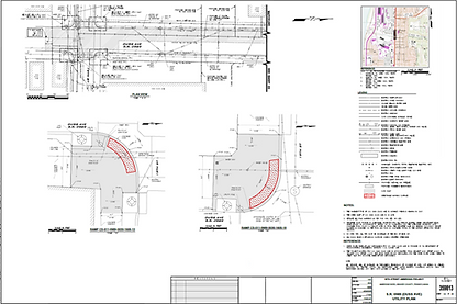
Housing Development Plans
We do drawings for Housing Developments, including all complimentary information (existing utilities, topographic contours, hidrography, transportation, etc.). We can do research in public sources for additional data, such as adjoiner names, topography, vicinity maps, existing utility information, or on-site specific survey if our clients need it.
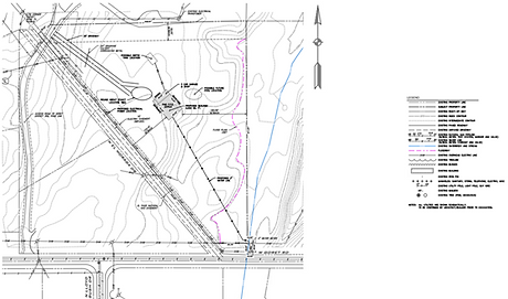
Well Sites Drilling Profiles
GSP International has developed customized Lisp routines to draw plan and profile drilling trajectories, based on X, Y & Z coordinates from a TXT file. We can add any information needed to both layouts as needed (parcel and owner data, existing features, X-Y-Z graphic profiles, etc.)

